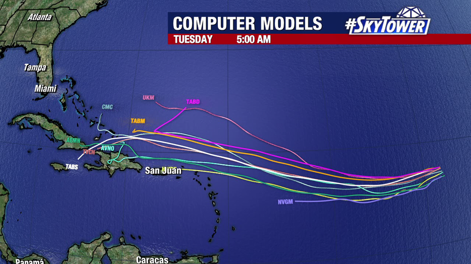
The National Hurricane Center (NHC) continues to monitor Invest 94L, a tropical disturbance currently located in the central Atlantic Ocean. As of October 16, 2024, this system presents a medium chance of developing into a tropical depression later this week as it moves westward. Its path suggests it could impact areas such as the Leeward Islands, Puerto Rico, and the U.S. Virgin Islands, which are urged to stay updated on forecast changes.
H2: Current Status and Forecast for Invest 94L
As of the latest data, Invest 94L consists of disorganized thunderstorms and weak winds, with speeds around 30 mph (48 km/h). The system is currently situated over relatively cool waters, which has limited its immediate development. However, the NHC predicts that environmental conditions will become more favorable mid to late this week as it moves into warmer waters, giving the disturbance a higher chance of intensifying into a tropical depression.
The storm’s west-northwest trajectory suggests that it could bring heavy rains and tropical winds to parts of the Caribbean, including the Leeward Islands. If the disturbance strengthens, it may develop further into a named storm as it approaches these regions later in the week.
Key Areas of Concern
- Leeward Islands & Puerto Rico: Residents and travelers should monitor developments closely, as Invest 94L is expected to approach by the weekend.
- Central America: In addition to Invest 94L, a new area of low pressure is forming in the western Caribbean. Even if this area doesn’t develop into a tropical cyclone, it will likely bring heavy rainfall to Honduras, Nicaragua, and other parts of Central America by the end of the week.
What is an “Invest”?
An invest is a designated area of interest being monitored by meteorologists for potential tropical cyclone development. The term helps forecasters focus their analysis and models on a specific disturbance. Once an invest shows consistent development signs, it can be upgraded to a tropical depression or a named storm depending on intensity.
Monitoring Tools and Updates
Invest 94L’s development can be tracked in real-time through services like Zoom Earth, which provides satellite imagery and forecasting models. Forecasts are updated frequently, so it is important for people in the Caribbean to stay tuned to official channels like the National Hurricane Center for any new developments or alerts.
External Resources for Tracking:
- NHC’s Tropical Outlook: National Hurricane Center
- Zoom Earth Tracker: Zoom Earth
Internal Resource for Further Reading
To stay informed about evolving tropical weather systems and the Atlantic hurricane season, check out latest news updates on Newsify.
Preparedness Tips
With the potential for Invest 94L to strengthen, residents and travelers in affected regions should:
- Monitor daily weather updates from trusted sources.
- Review emergency kits and evacuation plans.
- Stay alert for warnings from local authorities and the NHC.
This is a crucial time during the peak of hurricane season, which runs from June 1 to November 30, with October being especially active for tropical systems.


Leave a Reply